South Walton, located on Florida's Emerald Coast, is a prime example of how coastal regions can balance tourism with shoreline preservation. The area uses strict regulations and nature-based solutions to combat challenges like hurricanes, flooding, and erosion. Unlike urbanized regions like Southeast Florida, which rely on heavy infrastructure, or Tampa Bay's mixed approach, South Walton focuses on protecting its dunes and rare coastal dune lakes through setbacks, vegetation preservation, and public education.
Key takeaways:
- South Walton emphasizes natural defenses like dune protection, setbacks, and revegetation to safeguard its coastline.
- Southeast Florida employs engineered solutions such as seawalls, pumps, and beach nourishment to protect dense urban areas from rising sea levels and storm surges.
- Tampa Bay combines natural methods (mangrove restoration, living shorelines) with infrastructure upgrades to manage risks from shallow bays and storm surges.
Each region faces unique risks and uses tailored strategies to mitigate them. South Walton's focus on preserving its natural beauty aligns with its reliance on tourism, while urban areas prioritize engineered defenses to protect valuable infrastructure. The contrast highlights how geography and development shape resilience efforts.
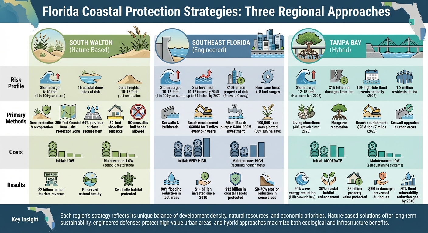
Coastal Protection Strategies Comparison: South Walton vs Southeast Florida vs Tampa Bay
1. South Walton
Risk Profile
South Walton's coastline faces serious challenges from hurricanes, storm surge, flooding, and coastal erosion. The shoreline continues to recede, and the dunes - natural barriers against storms - are deteriorating. According to the U.S. Army Corps of Engineers, high bluffs and protective dunes in the area are being severely impacted by hurricane forces, leaving the region increasingly vulnerable to future storms.
Adding to these concerns, South Walton is home to 16 coastal dune lakes, which play a critical role in flood management and support local wildlife. However, these lakes are at risk from pollution and poorly managed stormwater. Any disruption to the surrounding dune systems or improper handling of stormwater runoff can weaken the lakes' resilience and reduce the beaches' ability to endure severe weather.
To address these challenges, local authorities have implemented some of Florida's strictest coastal regulations.
Regulatory Framework
Walton County has adopted a proactive approach to protect its coastline. Through its Coastal Management Element, the county enforces rigorous rules aimed at safeguarding natural defenses. For instance, seawalls, bulkheads, revetments, and riprap are strictly prohibited in key coastal protection zones. Instead, the county promotes nature-based solutions to manage erosion and storm impacts. Additionally, construction seaward of the Coastal Construction Control Line (CCCL) is heavily restricted, with exceptions only for structures like boardwalks or beach access points.
One of the standout policies is the Coastal Dune Lake Protection Zone (CDLPZ), which extends 300 feet from the edge of each dune lake. Within this zone, at least 60% of any parcel must remain pervious surface to allow natural water absorption. Shoreline setbacks require a minimum 50-foot buffer from the mean high water line or coastal wetlands, with only narrow, perpendicular access paths permitted to minimize disruption. Native vegetation along these areas must also be preserved. Moreover, septic tanks are banned near coastal wetlands, dune systems, and dune lakes unless no central sewer system is available and health department approval is obtained.
These regulations form the backbone of South Walton's strategy to strengthen its natural resilience while maintaining its ecological integrity.
Protection Strategies
South Walton prioritizes nature-based solutions over hard engineering to protect its coastline. The county actively supports dune revegetation projects and installs sand fences on both public and private properties. Developers are required to plant sea oats and implement erosion control measures like hay bales and silt barriers recommended by the Florida Department of Environmental Protection (FDEP).
Beach nourishment projects, backed by studies from the U.S. Army Corps of Engineers, aim to restore the width of the shoreline while using sand that matches the region's iconic white beaches. These efforts not only reduce hurricane damage but also maintain the area's natural beauty.
Public awareness campaigns also play a key role. The county promotes "stay off dunes" messaging to prevent erosion caused by foot traffic. Meanwhile, the "Leave No Trace" ordinance ensures that all beach gear is removed overnight. This rule not only protects nesting sea turtles but also keeps the beaches clear for emergency vehicle access.
Through these combined efforts, South Walton continues to strengthen its defenses while preserving its unique coastal environment.
2. Southeast Florida
Risk Profile
Southeast Florida - which includes Miami-Dade, Broward, Palm Beach, and Martin counties - faces the greatest coastal risks in Florida. This area combines low elevation, dense urban development, and billions of dollars in infrastructure with the effects of rising sea levels. Forecasts predict 10–17 inches of sea-level rise by 2040 and as much as 54 inches by 2070.
Unlike South Walton, where dunes are the primary defense, Southeast Florida deals with frequent tidal flooding. In neighborhoods like Miami Beach, tidal flooding now happens dozens of times a year, compared to just a handful of events annually in the 1990s. The region is also highly vulnerable to storm surges. FEMA models estimate 10–15 foot surges during a 1-in-100-year storm, significantly higher than South Walton’s 6–10 feet. This increased risk is due to the region’s proximity to the Atlantic and shallow coastal waters. During Hurricane Irma in 2017, the area experienced surges of 4–8 feet. Broward County has identified over $10 billion in property value in areas at risk from tidal flooding and storm surges when planning for 2 feet of sea-level rise.
Another pressing issue is saltwater intrusion into the Biscayne Aquifer, which has already advanced several miles inland in parts of Miami-Dade County. This threatens the region’s water supply and has forced utilities to relocate wellfields at costs reaching hundreds of millions of dollars. These challenges require a regulatory approach designed for urban environments.
Regulatory Framework
The Southeast Florida Regional Climate Change Compact, established in 2010, is one of the first multi-county climate governance initiatives in the U.S. It coordinates sea-level rise projections and resilience strategies across four counties, ensuring that climate risks are integrated into comprehensive plans and infrastructure projects. Unlike the localized management seen in South Walton, this approach emphasizes regional collaboration.
Miami-Dade County has strict regulations, including 75-foot shoreline setbacks or 25% of lot depth (whichever is greater) for lots under 200 feet. The county prohibits seawalls and rip-rap, instead encouraging living shorelines and sewer connections to adapt to its urban density. Additionally, 60% of coastal zone surfaces must remain pervious to support drainage. Local governments have designated Adaptation Action Areas to focus zoning changes and investments on areas vulnerable to flooding and storm surges. New building codes now require structures to be elevated with "freeboard" above FEMA’s base flood elevations, exceeding state standards.
Protection Strategies
Southeast Florida employs a mix of large-scale engineering projects and nature-based solutions. Miami Beach, for example, launched a $400–500 million Comprehensive Resilience Plan after severe king tides in 2016. The plan raised streets by 1.5–2 feet and installed high-capacity pumps, cutting flooding by 90% in test areas. Beach nourishment, another key initiative, costs around $500 million and involves renourishing 7 miles of shoreline every 5–7 years with 1–2 million cubic yards of sand.
In Broward County, over 100,000 sea oats were planted to stabilize 5 miles of shoreline, with an 80% survival rate even after Hurricane Ian. Living shorelines featuring mangroves and oyster reefs help protect urban waterways, while U.S. Army Corps of Engineers projects have reduced erosion by 50–70% in some areas. Since 2010, the region has invested more than $1 billion in resilience efforts, safeguarding an estimated $12 billion in coastal assets. This scale of investment and planning far surpasses the more rural strategies seen in South Walton.
3. Tampa Bay/Southwest Florida
Risk Profile
Unlike South Walton's protective dunes, Tampa Bay and Southwest Florida face much tougher challenges when it comes to coastal risks. The large, shallow bays - like Tampa Bay and Charlotte Harbor - magnify storm surges far more than South Walton's open Gulf coastline. A stark example is Hurricane Ian in 2022, which brought storm surges of 12–15 feet to parts of the region, causing US$15 billion in damages. This event highlighted the vulnerabilities of the area's densely populated waterfronts. Beyond storm surges, the region also deals with "sunny day" flooding. By 2023, Pinellas County recorded over 10 high-tide flood events annually, a 20% rise since 1985. Low-lying neighborhoods in Tampa and St. Petersburg, along with barrier islands like Clearwater Beach and Fort Myers Beach, are particularly at risk. Compounding these issues are aging drainage systems and hardened shorelines that worsen flooding from tides and heavy rainfall. Adding to the concern, sea levels are projected to rise by 1–2 feet by 2050, putting around 1.2 million residents in harm's way. These unique challenges call for specialized strategies and regulations to manage the risks effectively.
Regulatory Framework
Tampa Bay and Southwest Florida's coastal management operates under Florida's statewide Coastal Construction Control Line (CCCL) and the Beach and Shore Preservation Act, both overseen by the Florida Department of Environmental Protection. The Tampa Bay Regional Planning Council plays a key role in resilience planning, using sea level rise scenarios to inform evacuation routes, redevelopment plans, and land-use policies. Local governments often enforce rules that limit construction near protective zones and require robust stormwater management systems. Unlike South Walton, which focuses on dune protection, Tampa Bay emphasizes preserving and restoring mangroves, tidal marshes, and estuarine buffers. Many areas also restrict new seawalls and implement better water runoff management practices. After storms, rebuilding efforts typically follow FEMA and local elevation standards aimed at creating safer structures. However, older developments built before modern regulations remain a challenge to retrofit.
Protection Strategies
To address these risks, local authorities use a mix of engineered and natural defenses. In 2023, the region invested approximately US$25 million to renourish 17 miles of shoreline, which helped protect an estimated US$5 billion in property value. These projects widened beaches and increased dune volume, providing a buffer against storm surges similar to South Walton's approach. The use of living shorelines - featuring mangroves and oyster reefs - has grown by 40% since 2020. In Hillsborough Bay, these projects have reduced wave energy by up to 60% while enhancing coastal habitats by 30%. Sarasota Bay has seen similar successes; targeted mangrove restoration protected 2 miles of shoreline during Hurricane Ian, saving an estimated US$3 million in damages. The Tampa Bay Regional Planning Council's 2023 Resilient Tampa Bay Plan aims to cut flood vulnerability by 50% by 2040 through infrastructure improvements and the development of green corridors. Urban areas also rely on seawall upgrades and stormwater system retrofits to combat frequent tidal flooding. However, these measures can sometimes shift erosion problems to other areas and may not fully resolve drainage issues from heavy rains. This blend of strategies highlights the complexity of protecting a highly developed urban coastline compared to the more focused efforts seen in South Walton.
sbb-itb-d06eda6
Ep3: How to increase coastal resilience with nature-based solutions | MasterScience | Mike Beck
Advantages and Disadvantages by Region
This section highlights how different regions approach coastal resilience, weighing the benefits and challenges of their chosen strategies. Each region prioritizes unique solutions, reflecting its specific environmental, economic, and social needs.
In South Walton, the focus on preserving dunes and banning seawalls allows for natural sand movement and safeguards sea turtle nesting areas. However, these strict setback policies can limit oceanfront development compared to more urbanized areas. On the other hand, Southeast Florida relies heavily on seawalls, bulkheads, and frequent beach nourishment. While these measures protect densely developed coastlines in the short term, they can lead to increased water turbidity, harm intertidal zones, and come with steep construction and maintenance costs. Meanwhile, Tampa Bay and Southwest Florida take a mixed approach, incorporating mangrove restoration, living shorelines, and selective beach nourishment. These strategies deliver ecological perks like improved fish habitats, better water filtration, and carbon storage, while also adapting naturally to rising seas. However, their success depends on having enough space for these systems to migrate inland.
Comparing Costs Across Regions
Financial considerations vary widely. South Walton’s approach involves relatively low initial construction costs but requires ongoing efforts like enforcement, public education, and periodic dune restoration after storms . In contrast, Southeast Florida’s engineered solutions demand significant upfront investment and recurring maintenance expenses. Tampa Bay’s nature-based methods fall in the middle, with moderate initial costs and lower long-term expenses due to the self-sustaining nature of these systems.
Addressing Vulnerabilities and Risks
South Walton’s setbacks allow for natural shoreline migration, though some infrastructure remains at risk. In Southeast Florida, rigid coastal armoring, such as seawalls, poses challenges like overtopping, groundwater flooding, and “coastal squeeze,” where beaches lose their ability to move inland. Tampa Bay’s approach, with mangrove restoration and living shorelines, offers adaptability to rising seas and stronger storms, as these systems can grow upward and shift inland - provided there’s enough space.
Community Involvement and Engagement
South Walton emphasizes community-driven efforts to bolster coastal resilience. Platforms like sowal.co serve as a hub for sharing updates on beach rules, dune protection, and local conditions, helping to align visitor behavior with conservation goals. This grassroots approach contrasts with the more centralized, infrastructure-heavy strategies seen in Southeast Florida and Tampa Bay.
Summary of Regional Strategies
The table below provides a concise comparison of the key factors discussed:
| Factor | South Walton | Southeast Florida | Tampa Bay/Southwest Florida |
|---|---|---|---|
| Primary Methods | Dune protection, setbacks, nature-based solutions | Seawalls, bulkheads, and large-scale beach nourishment | Mixed methods: living shorelines, mangroves, targeted nourishment |
| Ecological Effects | Preserves natural sand movement and turtle habitats | Increases turbidity, disrupts intertidal zones, and turtle nesting | Supports fish nurseries, water filtration, and carbon storage |
| Short-Term Costs | Low construction costs, with enforcement and education expenses | Very high capital costs for seawalls and nourishment projects | Moderate upfront investments |
| Long-Term Costs | Low maintenance, with periodic dune restoration | High recurring costs for renourishment cycles | Lower lifecycle costs due to self-maintaining systems |
| Future Risk Performance | Allows shoreline migration but leaves some infrastructure vulnerable | Vulnerable to overtopping, flooding, and coastal squeeze | Resilient to rising seas and storms, with upward and landward growth |
| Tourism & Access | Preserves natural beauty and encourages compliance | Urban beaches face conflicts between access and preservation | Boosts tourism with conserved habitats and recreational opportunities |
Each region’s strategy reflects its unique balance of ecological preservation, cost management, and community priorities, showcasing the diverse approaches to tackling coastal resilience.
Conclusion
South Walton's nature-focused strategies, contrasted with Southeast Florida's engineered defenses and Tampa Bay's blended approach, offer valuable insights into coastal resilience. By strictly banning seawalls and prioritizing the preservation of natural dune systems - like mandating 60% pervious surfaces within 300 feet of coastal dune lake protection zones - South Walton demonstrates how natural solutions can safeguard shorelines while maintaining the tourism industry that thrives on its pristine beaches. On the other hand, urban areas provide examples of integrated planning and funding methods, such as Southeast Florida's federal–state partnerships, which have successfully restored over 100 miles of shoreline since 2000.
The differences in these approaches highlight the varied challenges and successes along Florida's coastlines. For instance, South Walton maintains dunes at heights of 10–15 feet post-restoration and generates over $2 billion annually from tourism tied to its clean beaches. Meanwhile, urban coastal areas experience significant erosion, losing 2–3 feet annually in heavily armored sections. Urban regions can take a page from South Walton’s playbook by moving development inland from dunes and avoiding hard structures that disrupt sediment flow and accelerate erosion. Conversely, South Walton could enhance its efforts by incorporating hybrid strategies - such as combining beach nourishment with its revegetation programs, conducting annual dune assessments to meet Florida DEP standards, and working with the U.S. Army Corps of Engineers on biennial renourishment projects.
The key to lasting coastal protection lies in blending natural defenses with thoughtful regulations. Striking a balance between development, tourism, and conservation is crucial for building long-term resilience. South Walton's Coastal Management Element and Habitat Conservation Plan illustrate how effective policies can protect both property and sensitive ecosystems. Additionally, platforms like sowal.co play a vital role by educating visitors on beach safety, dune preservation, and Leave No Trace practices, aligning tourist behavior with conservation efforts.
While each region's approach reflects its specific needs and priorities, one universal truth stands out: preserving natural systems today ensures ecological well-being and economic stability for the future. The most effective resilience strategies combine natural buffers with smart development practices, as evidenced by South Walton’s setback policies and Tampa Bay’s use of green infrastructure following Hurricane Irma.
FAQs
What makes South Walton's coastal protection strategies unique compared to other regions in Florida?
South Walton takes a thoughtful approach to coastal protection by emphasizing natural methods like restoring sand dunes and planting vegetative buffers. These strategies not only help maintain the area's scenic charm but also strengthen its ability to withstand storms and combat erosion.
On the other hand, places such as Southeast Florida and Tampa Bay often turn to hard infrastructure solutions, like seawalls and storm surge barriers. While these can be effective in certain situations, they sometimes interfere with natural coastal ecosystems and processes. South Walton's preference for living shorelines highlights its dedication to protecting both the environment and the community in harmony.
What nature-based methods are used in South Walton to prevent coastal erosion?
While the article doesn’t dive into the exact nature-based techniques employed in South Walton to combat coastal erosion, these methods typically involve approaches like planting native vegetation, restoring sand dunes, and establishing living shorelines. These strategies not only help prevent erosion but also maintain the area's natural beauty and ecological balance.
Why are coastal dune lakes essential to South Walton's resilience efforts?
Coastal dune lakes are a key part of South Walton's approach to dealing with environmental challenges. These rare ecosystems serve as natural shields, helping to reduce the impact of storm surges and flooding on nearby neighborhoods and infrastructure. They also play a big part in keeping water clean by filtering runoff and support a rich variety of plants and wildlife.
Protecting these lakes not only helps South Walton face climate-related issues but also ensures the area's stunning landscapes and diverse ecosystems are preserved for generations to come.